- Πρώτη Πρωτεύουσα της Αρχαίας Μακεδονίας")

Υπέρυθρες και Ορατές Δορυφορικές Εικόνες

|
|
|
|
Μετεωρολογικοί Δορυφόροι |
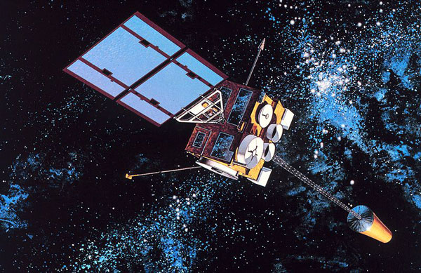 |
Πρόκειται για είδος δορυφόρου που πρωτίστως χρησιμοποιείται για την καταγραφή του καιρού και κλίματος της Γης. Οι δορυφόροι είναι είτε πολικής τροχιάς, που παρακολουθούν την ίδια ζώνη της Γης κάθε 12 ώρες, είτε γεωστατικής τροχιάς, που παρακολουθούν μόνιμα ένα συγκεκριμένο τμήμα της Γης με τροχιά πάνω από τον ισημερινό καθώς κινείται με την ταχύτητα περιστροφής της. Οι μετεωρολογικοί δορυφόροι παρακολουθούν περισσότερα πράγματα εκτός από σύννεφα και καιρικά συστήματα. Φωτισμός πόλεων, πυρκαγιές, επιπτώσεις μόλυνσης, αμμοθύελλες και σκονοθύελλες, χιονοκάλυψη και παγοκάλυψη, όρια θαλασσίων ρευμάτων, ροή ενέργειας, κλπ, και άλλοι τύποι περιβαντολλογικής πληροφόρησης συλλέγονται από τους μετεωρολογικούς δορυφόρους. Οι δορυφορικές εικόνες βοηθούν επίσης στην παρακολούθηση και δραστηριότητα των ηφαιστίων και του καπνού από πυρκαγιές δασών. Οι εικόνες Ορατού Φωτός από τους μετεωρολογικούς δορυφόρους κατά τη διάρκεια του φωτός της ημέρας, είναι εύκολο να ερμηνευτούν ακόμα κι από τον μέσο άνθρωπο. Σύννεφα, νεφικά συστήματα όπως μέτωπα και τροπικές καταιγίδες, λίμνες, δάση, βουνά, χιόνι, πάγος, πυρκαγιές και μόλυνση όπως καπνός, αιθαλομίχλη, σκόνη και αχλύς είναι εμφανώς αναγνωρίσιμα. Ακόμα και ο άνεμος μπορεί να καταγραφεί από τα σχήματα των νεφών, ευθυγραμμίσεις και κίνηση από διαδοχικές εικόνες. Ορατό Φάσμα Οι εικόνες Ορατού Φωτός από τους μετεωρολογικούς δορυφόρους κατά τη διάρκεια του φωτός της ημέρας, είναι εύκολο να ερμηνευτούν ακόμα κι από τον μέσο άνθρωπο. Σύννεφα, νεφικά συστήματα όπως μέτωπα και τροπικές καταιγίδες, λίμνες, δάση, βουνά, χιόνι, πάγος, πυρκαγιές και μόλυνση όπως καπνός, αιθαλομίχλη, σκόνη και αχλύς είναι εμφανώς αναγνωρίσιμα. Ακόμα και ο άνεμος μπορεί να καταγραφεί από τα σχήματα των νεφών, ευθυγραμμίσεις και κίνηση από διαδοχικές εικόνες. Υπέρυθρο Φάσμα Οι θερμικές και υπέρυθρες εικόνες που καταγράφονται από αισθητήρες που ονομάζονται ραδιόμετρα σάρωσης, δίνουν τη δυνατότητα σε έναν εκπαιδευμένο αναλυτή να ορίσει τα ύψη νεφών και τύπους, να υπολογίσει τις θερμοκρασίες ξηράς και υδάτων και να προσδιορίσει χαρακτηριστικά επιφανειών των ωκεανών. Οι υπέρυθρες εικόνες μπορούν να χρησιμοποιηθούν αποτελεσματικά σε τροπικούς κυκλώνες με ορατό σχήμα "ματιού", χρησιμοποιώντας την τεχνική Dvorak, όπου η διαφορά μεταξύ της θερμοκρασίας του θερμού ματιού και των ψυχρών κορυφών των παριβάλλοντων νεφών, μπορεί να χρησιμοποιηθεί για να οριστεί η έντασή τους (ψυχρότερες κορυφές νεφών γενικά καταδεικνύουν μια πιο έντονη θύελλα). Οι υπέρυθρες εικόνες καταδεικνύουν περιδινήσεις των ωκεανών ή στρόβιλους και χαρτογραφούν ρεύματα όπως το Ρεύμα του Κόλπου που είναι πολύ χρήσιμα στην ναυσιπλοϊα. Οι ψαράδες και αγρότες δίνουν μεγάλη σημασία στη γνώση των θερμοκρασιών θάλασσας και ξηράς για να προστατεύσουν τη σοδειά τους από τον παγετό ή να αυξήσουν τα αλιεύματά τους από τη θάλασσα. Ακόμα και οι επιρροές από το Ελ Νίνιο μπορεί να εντοπιστούν. Χρησιμοποιώντας ψηφιακές τεχνικές χρωματισμού, οι γκρίζες διαβαθμίσεις των εικόνων μπορούν να μετατραπούν σε έγχρωμες για ευκολότερη ταυτοποίηση της επιθυμητής πληροφορίας. Τύποι δορυφόρων Υπάρχουν δύο τύποι μετεωρολογικών δορυφόρων: Γεωστατικής και Πολικής τροχιάς. Οι γεωστατικοί μετεωρολογικοί δορυφόροι έχουν τροχιά γύρω από τη Γη πάνω από τον ισημερινό σε υψόμετρο 35.880 χλμ (22.300 μίλια). Λόγω αυτής της τροχιάς, παραμένουν στάσιμοι σε αντιστοιχία με την περιστρεφόμενη Γη, κι έτσι καταγράφουν εικόνες ολόκληρου του ημισφαίριου από κάτω συνεχώς με τους αισθητήρες ορατού φωτός και υπερύθρων. Τα μέσα μαζικής ενημέρωσης, χρησιμοποιούν ενιαίες ή κινούμενες εικόνες για τα καθημερινά δελτία καιρού. Οι δορυφόροι πολικής τροχιάς περιστρέφονται γύρω από τη Γη στο τυπικό υψόμετρω των 850 χλμ (530 μίλια) σε μια τροχιά από βορρά προς νότο (ή αντίστροφα), περνώντας πάνω από τους πόλους κατά τη διάρκεια της συνεχούς πτήσης τους. Οι δορυφόροι πολικής τροχιάς βρίσκονται σε τροχιά σύγχρονη με τον ήλιο, κάτι που σημαίνει πως είναι ικανοί να παρατηρούν οποιοδήποτε μέρος πάνω στη Γη δύο φορές και με τις ίδιες συνθήκες φωτισμού αφού ακολουθούν το ηλιακό φως. Οι δορυφόροι αυτοί παρέχουν πολύ καλύτερη ανάλυση από τους αντίστοιχους γεωστατικούς λόγω της εγγύτητας τους προς τη Γη. |