Global Forecast System (GFS) Maps

Resolution 1° for Europe - Resolution 0.25° for Greece


Precipitation and Form of Precipitation over Europe

(In the 3 hrs)
Load-Time depends on Connection-Speed

(In the 6 hrs)
Load-Time depends on Connection-Speed

(In the 12 hrs)
Load-Time depends on Connection-Speed

GFS-GR

GFS-GR

GFS-GR

According to the colour index:

colindex

the precipitation will vary from very light (0.1 mm-light cyan colour) to very heavy (55 mm- red colour).
 

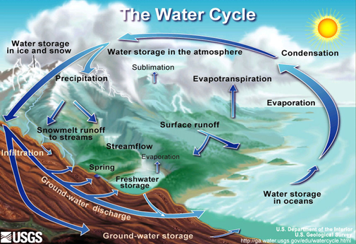
The Water Cycle

 
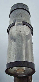
Analog Rain Gauge
Types of Precipitation
  • Liquid precipitation:

    • Drizzle (DZ)
    • Drizzle is a light rain precipitation consisting of liquid water drops smaller than those of rain, and generally smaller than 0.5 mm (0.02 in.) in diameter. Drizzle is normally produced by low stratiform clouds and stratocumulus clouds. Precipitation rates due to drizzle are on the order of a millimetre per day or less at the ground. Owing to the small size of drizzle drops, under many circumstances drizzle largely evaporates before reaching the surface, and so may be undetected by observers on the ground. The METAR code for drizzle is DZ.

    • Rain (RA)
    • Rain is liquid precipitation, as opposed to non-liquid kinds of precipitation such as snow, hail and sleet. Rain requires the presence of a thick layer of the atmosphere to have temperatures above the melting point of water near and above the Earth's surface. On Earth, it is the condensation of atmospheric water vapor into drops of water heavy enough to fall, often making it to the surface. Two processes, possibly acting together, can lead to air becoming saturated leading to rainfall: cooling the air or adding water vapor to the air. Virga is precipitation that begins falling to the earth but evaporates before reaching the surface. it is one of the ways air can become saturated. Precipitation forms via collision with other rain drops or ice crystals within a cloud. Rain drops range in size from oblate, pancake-like shapes for larger drops, to small spheres for smaller drops.
  • Freezing precipitation:

    • Freezing drizzle (FZDZ)
    • Freezing drizzle is drizzle that freezes on contact with the ground or an object at or near the surface. Its METAR code is FZDZ. When freezing drizzle accumulates on land it creates an icy layer of glaze. Freezing drizzle alone does not generally result in significant ice accumulations due to its light, low-intensity nature.

    • Freezing rain (FZRA)
    • Freezing rain is the name given to rain that falls when surface temperatures are below freezing. The raindrops become supercooled while passing through a sub-freezing layer of air, many hundred feet (or meters), just above the surface, and then freeze upon impact with any object they encounter. The resulting ice, called glaze, can accumulate to a thickness of several centimeters. The METAR code for freezing rain is FZRA.
  • Frozen precipitation:

    • Snow (SN)
    • Snow is a form of precipitation within the Earth's atmosphere in the form of crystalline water ice, consisting of a multitude of snowflakes that fall from clouds. Since snow is composed of small ice particles, it is a granular material. It has an open and therefore soft structure, unless packed by external pressure. Snowflakes come in a variety of sizes and shapes. Types which fall in the form of a ball due to melting and refreezing, rather than a flake, are known as graupel, ice pellets or snow grains. Snowfall amount and its related liquid equivalent precipitation amount are determined using a variety of different rain gauges.

    • Snow grains (SG)
    • Snow grains are a form of precipitation characterized as white, opaque grains of ice, very small mm and fairly flat or elongated and unlike Snow pellets they don't bounce or break up on impact. very small amounts fall, mostly from Stratus or Fog but Never in the form of a shower. The METAR code for snow grains is SG.

    • Ice pellets/Sleet (PL)
    • Ice pellets (also referred to as sleet by the United States National Weather Service) are a form of precipitation consisting of small, translucent balls of ice. Ice pellets usually are smaller than hailstones. They often bounce when they hit the ground, and generally do not freeze into a solid mass unless mixed with freezing rain. The METAR code for ice pellets is PL.

    • Hail (GR)
    • Hail is a form of solid precipitation. It consists of balls or irregular lumps of ice, each of which is referred to as a hail stone. Hail stones on Earth consist mostly of water ice and measure between 5 millimetres (0.20 in) and 200 millimetres (7.9 in) in diameter, with the larger stones coming from severe thunderstorms. The METAR reporting code for hail 5 millimetres (0.20 in) or greater in diameter is GR, while smaller hailstones and graupel are coded GS. Hail is possible within most thunderstorms as it is produced by cumulonimbus (thunderclouds), and within 2 nautical miles (3.7 km) of the parent storm. Hail formation requires environments of strong, upward motion of air with the parent thunderstorm (similar to tornadoes) and lowered heights of the freezing level. Hail is most frequently formed in the interior of continents within the mid-latitudes of Earth, with hail generally confined to higher elevations within the tropics.

    • Snow pellets/Graupel (GS)
    • Graupel (also called soft hail or snow pellets). METAR code GS, refers to precipitation that forms when supercooled droplets of water are collected and freeze on a falling snowflake, forming a 2-5 mm ball of rime. The term graupel is the German word for this meteorological phenomenon. Graupel is sometimes referred to as small hail, although the World Meteorological Organization defines small hail as snow pellets encapsulated by ice.

    • Ice crystals (IC)
    • Diamond dust is a ground-level cloud composed of tiny ice crystals. This meteorological phenomenon is also referred to simply as ice crystals and is reported in the METAR code as IC. Diamond dust generally forms under otherwise clear or nearly clear skies, so it is sometimes referred to as clear-sky precipitation. It is most commonly observed in Antarctica and the Arctic, but it can occur anywhere with a temperature well below freezing. In Polar regions diamond dust may continue for several days without interruption.

Precipitation and Form of Precipitation over Northern Hemisphere

(In the 3 hrs)
Load-Time depends on Connection-Speed

(In the 6 hrs)
Load-Time depends on Connection-Speed

(In the 12 hrs)
Load-Time depends on Connection-Speed

GFS-GR

GFS-GR

GFS-GR

According to the colour index:

colindex

the precipitation will vary from very light (0.1 mm-light cyan colour) to very heavy (55 mm- red colour).
 

The Water Cycle

 
Analog Rain Gauge
Types of Precipitation
  • Liquid precipitation:

    • Drizzle (DZ)
    • Drizzle is a light rain precipitation consisting of liquid water drops smaller than those of rain, and generally smaller than 0.5 mm (0.02 in.) in diameter. Drizzle is normally produced by low stratiform clouds and stratocumulus clouds. Precipitation rates due to drizzle are on the order of a millimetre per day or less at the ground. Owing to the small size of drizzle drops, under many circumstances drizzle largely evaporates before reaching the surface, and so may be undetected by observers on the ground. The METAR code for drizzle is DZ.

    • Rain (RA)
    • Rain is liquid precipitation, as opposed to non-liquid kinds of precipitation such as snow, hail and sleet. Rain requires the presence of a thick layer of the atmosphere to have temperatures above the melting point of water near and above the Earth's surface. On Earth, it is the condensation of atmospheric water vapor into drops of water heavy enough to fall, often making it to the surface. Two processes, possibly acting together, can lead to air becoming saturated leading to rainfall: cooling the air or adding water vapor to the air. Virga is precipitation that begins falling to the earth but evaporates before reaching the surface. it is one of the ways air can become saturated. Precipitation forms via collision with other rain drops or ice crystals within a cloud. Rain drops range in size from oblate, pancake-like shapes for larger drops, to small spheres for smaller drops.
  • Freezing precipitation:

    • Freezing drizzle (FZDZ)
    • Freezing drizzle is drizzle that freezes on contact with the ground or an object at or near the surface. Its METAR code is FZDZ. When freezing drizzle accumulates on land it creates an icy layer of glaze. Freezing drizzle alone does not generally result in significant ice accumulations due to its light, low-intensity nature.

    • Freezing rain (FZRA)
    • Freezing rain is the name given to rain that falls when surface temperatures are below freezing. The raindrops become supercooled while passing through a sub-freezing layer of air, many hundred feet (or meters), just above the surface, and then freeze upon impact with any object they encounter. The resulting ice, called glaze, can accumulate to a thickness of several centimeters. The METAR code for freezing rain is FZRA.
  • Frozen precipitation:

    • Snow (SN)
    • Snow is a form of precipitation within the Earth's atmosphere in the form of crystalline water ice, consisting of a multitude of snowflakes that fall from clouds. Since snow is composed of small ice particles, it is a granular material. It has an open and therefore soft structure, unless packed by external pressure. Snowflakes come in a variety of sizes and shapes. Types which fall in the form of a ball due to melting and refreezing, rather than a flake, are known as graupel, ice pellets or snow grains. Snowfall amount and its related liquid equivalent precipitation amount are determined using a variety of different rain gauges.

    • Snow grains (SG)
    • Snow grains are a form of precipitation characterized as white, opaque grains of ice, very small mm and fairly flat or elongated and unlike Snow pellets they don't bounce or break up on impact. very small amounts fall, mostly from Stratus or Fog but Never in the form of a shower. The METAR code for snow grains is SG.

    • Ice pellets/Sleet (PL)
    • Ice pellets (also referred to as sleet by the United States National Weather Service) are a form of precipitation consisting of small, translucent balls of ice. Ice pellets usually are smaller than hailstones. They often bounce when they hit the ground, and generally do not freeze into a solid mass unless mixed with freezing rain. The METAR code for ice pellets is PL.

    • Hail (GR)
    • Hail is a form of solid precipitation. It consists of balls or irregular lumps of ice, each of which is referred to as a hail stone. Hail stones on Earth consist mostly of water ice and measure between 5 millimetres (0.20 in) and 200 millimetres (7.9 in) in diameter, with the larger stones coming from severe thunderstorms. The METAR reporting code for hail 5 millimetres (0.20 in) or greater in diameter is GR, while smaller hailstones and graupel are coded GS. Hail is possible within most thunderstorms as it is produced by cumulonimbus (thunderclouds), and within 2 nautical miles (3.7 km) of the parent storm. Hail formation requires environments of strong, upward motion of air with the parent thunderstorm (similar to tornadoes) and lowered heights of the freezing level. Hail is most frequently formed in the interior of continents within the mid-latitudes of Earth, with hail generally confined to higher elevations within the tropics.

    • Snow pellets/Graupel (GS)
    • Graupel (also called soft hail or snow pellets). METAR code GS, refers to precipitation that forms when supercooled droplets of water are collected and freeze on a falling snowflake, forming a 2-5 mm ball of rime. The term graupel is the German word for this meteorological phenomenon. Graupel is sometimes referred to as small hail, although the World Meteorological Organization defines small hail as snow pellets encapsulated by ice.

    • Ice crystals (IC)
    • Diamond dust is a ground-level cloud composed of tiny ice crystals. This meteorological phenomenon is also referred to simply as ice crystals and is reported in the METAR code as IC. Diamond dust generally forms under otherwise clear or nearly clear skies, so it is sometimes referred to as clear-sky precipitation. It is most commonly observed in Antarctica and the Arctic, but it can occur anywhere with a temperature well below freezing. In Polar regions diamond dust may continue for several days without interruption.

Temperature at 850 hPa over Europe

(In the 3 hrs)
Load-Time depends on Connection-Speed

(In the 6 hrs)
Load-Time depends on Connection-Speed

(In the 12 hrs)
Load-Time depends on Connection-Speed

Celsius and Fahrenheit Conversion


°C       °F  


Enter a number representing a temperature in either the Celsius box or the Fahrenheit box and click on the Calculate button (or anywhere else other than the data field). This uses an adaptation of the formula to do the conversion but as you will see, provides decimal accuracy.

This converter requires the use of Javascript enabled and capable browsers. In the formulas below, / represents division, * represents multiplication, - subtraction, + addition and = is equal.

Tc = (5/9)*(Tf-32); Tc = temperature in degrees Celsius, Tf = temperature in degrees Fahrenheit.

For example, suppose you have a Fahrenheit temperature of 98.6 degrees and you wanted to convert it into degrees on the Celsius scale. Using the above formula, you would first subtract 32 from the Fahrenheit temperature and get 66.6 as a result. Then you multiply 66.6 by five-ninths and get the converted value of 37 degrees Celsius.

Below is the formula to convert a Celsius scale temperature into degrees on the Fahrenheit scale.

Tf = (9/5)*Tc+32; Tc = temperature in degrees Celsius, Tf = temperature in degrees Fahrenheit.

Assume that you have a Celsius scale temperature of 100 degrees and you wish to convert it into degrees on the Fahrenheit scale. Using the stated formula, you first multiply the Celsius scale temperature reading by nine-fifths and get a result of 180. Then add 32 to 180 and get the final converted result of 212 degrees on the Fahrenheit scale.

Below is another accepted conversion method that works just as well and perhaps might be easier to remember. No matter which direction you want to covert, Fahrenheit to Celsius or Celsius to Fahrenheit, always first add 40 to the number. Next, multiply by 5/9 or 9/5 just like the first method. Then, always subtract out the 40 you just added to yield the final result.

For an example of this method, we'll use the values we used in the initial example, 98.6 F and 37 C, which are equal.

To convert from F to C, try these calculations manually:.
98.6 + 40 = 138.6, and 138.6 * 5/9 = 77. For the final calculation, remove the 40. 77 - 40 = 37.

To convert from C to F, try these calculations manually:.

37 + 40 = 77, and 77 * 9/5 = 138.6. For the final calculation, remove the 40. 138.6 - 40 = 98.6.

The Celsius temperature scale is still sometimes referred to as the "centigrade" scale. Centigrade means "consisting of or divided into 100 degrees;" the Celsius scale, devised by Swedish Astronomer Andres Celsius (1701-1744) for scientific purposes, has 100 degrees between the freezing point (0 C) and boiling point (100 C) of pure water at sea level air pressure. The term Celsius was adopted in 1948 by an international conference on weights and measure.

Temperature at 850 hPa over Northern Hemisphere

(In the 3 hrs)
Load-Time depends on Connection-Speed

(In the 6 hrs)
Load-Time depends on Connection-Speed

(In the 12 hrs)
Load-Time depends on Connection-Speed

Celsius and Fahrenheit Conversion


°C       °F  


Enter a number representing a temperature in either the Celsius box or the Fahrenheit box and click on the Calculate button (or anywhere else other than the data field). This uses an adaptation of the formula to do the conversion but as you will see, provides decimal accuracy.

This converter requires the use of Javascript enabled and capable browsers. In the formulas below, / represents division, * represents multiplication, - subtraction, + addition and = is equal.

Tc = (5/9)*(Tf-32); Tc = temperature in degrees Celsius, Tf = temperature in degrees Fahrenheit.

For example, suppose you have a Fahrenheit temperature of 98.6 degrees and you wanted to convert it into degrees on the Celsius scale. Using the above formula, you would first subtract 32 from the Fahrenheit temperature and get 66.6 as a result. Then you multiply 66.6 by five-ninths and get the converted value of 37 degrees Celsius.

Below is the formula to convert a Celsius scale temperature into degrees on the Fahrenheit scale.

Tf = (9/5)*Tc+32; Tc = temperature in degrees Celsius, Tf = temperature in degrees Fahrenheit.

Assume that you have a Celsius scale temperature of 100 degrees and you wish to convert it into degrees on the Fahrenheit scale. Using the stated formula, you first multiply the Celsius scale temperature reading by nine-fifths and get a result of 180. Then add 32 to 180 and get the final converted result of 212 degrees on the Fahrenheit scale.

Below is another accepted conversion method that works just as well and perhaps might be easier to remember. No matter which direction you want to covert, Fahrenheit to Celsius or Celsius to Fahrenheit, always first add 40 to the number. Next, multiply by 5/9 or 9/5 just like the first method. Then, always subtract out the 40 you just added to yield the final result.

For an example of this method, we'll use the values we used in the initial example, 98.6 F and 37 C, which are equal.

To convert from F to C, try these calculations manually:.
98.6 + 40 = 138.6, and 138.6 * 5/9 = 77. For the final calculation, remove the 40. 77 - 40 = 37.

To convert from C to F, try these calculations manually:.

37 + 40 = 77, and 77 * 9/5 = 138.6. For the final calculation, remove the 40. 138.6 - 40 = 98.6.

The Celsius temperature scale is still sometimes referred to as the "centigrade" scale. Centigrade means "consisting of or divided into 100 degrees;" the Celsius scale, devised by Swedish Astronomer Andres Celsius (1701-1744) for scientific purposes, has 100 degrees between the freezing point (0 C) and boiling point (100 C) of pure water at sea level air pressure. The term Celsius was adopted in 1948 by an international conference on weights and measure.

Temperature & Dew Point at 2 meters in Europe

(In the 3 hrs)
Load-Time depends on Connection-Speed

(In the 6 hrs)
Load-Time depends on Connection-Speed

(In the 12 hrs)
Load-Time depends on Connection-Speed

GFS-GR

GFS-GR

GFS-GR

Celsius and Fahrenheit Conversion


°C       °F  


Enter a number representing a temperature in either the Celsius box or the Fahrenheit box and click on the Calculate button (or anywhere else other than the data field). This uses an adaptation of the formula to do the conversion but as you will see, provides decimal accuracy.

This converter requires the use of Javascript enabled and capable browsers. In the formulas below, / represents division, * represents multiplication, - subtraction, + addition and = is equal.

Tc = (5/9)*(Tf-32); Tc = temperature in degrees Celsius, Tf = temperature in degrees Fahrenheit.

For example, suppose you have a Fahrenheit temperature of 98.6 degrees and you wanted to convert it into degrees on the Celsius scale. Using the above formula, you would first subtract 32 from the Fahrenheit temperature and get 66.6 as a result. Then you multiply 66.6 by five-ninths and get the converted value of 37 degrees Celsius.

Below is the formula to convert a Celsius scale temperature into degrees on the Fahrenheit scale.

Tf = (9/5)*Tc+32; Tc = temperature in degrees Celsius, Tf = temperature in degrees Fahrenheit.

Assume that you have a Celsius scale temperature of 100 degrees and you wish to convert it into degrees on the Fahrenheit scale. Using the stated formula, you first multiply the Celsius scale temperature reading by nine-fifths and get a result of 180. Then add 32 to 180 and get the final converted result of 212 degrees on the Fahrenheit scale.

Below is another accepted conversion method that works just as well and perhaps might be easier to remember. No matter which direction you want to covert, Fahrenheit to Celsius or Celsius to Fahrenheit, always first add 40 to the number. Next, multiply by 5/9 or 9/5 just like the first method. Then, always subtract out the 40 you just added to yield the final result.

For an example of this method, we'll use the values we used in the initial example, 98.6 F and 37 C, which are equal.

To convert from F to C, try these calculations manually:.
98.6 + 40 = 138.6, and 138.6 * 5/9 = 77. For the final calculation, remove the 40. 77 - 40 = 37.

To convert from C to F, try these calculations manually:.

37 + 40 = 77, and 77 * 9/5 = 138.6. For the final calculation, remove the 40. 138.6 - 40 = 98.6.

The Celsius temperature scale is still sometimes referred to as the "centigrade" scale. Centigrade means "consisting of or divided into 100 degrees;" the Celsius scale, devised by Swedish Astronomer Andres Celsius (1701-1744) for scientific purposes, has 100 degrees between the freezing point (0 C) and boiling point (100 C) of pure water at sea level air pressure. The term Celsius was adopted in 1948 by an international conference on weights and measure.

Wind at 10 meters in Greece

(In the 3 hrs)
Load-Time depends on Connection-Speed

(In the 6 hrs)
Load-Time depends on Connection-Speed

the wind speed will vary from calm (0 knots - violet colour) to extremely strong (50+ knots - magenta colour)
According to the colour index:

colindex
 
Wind Convertion Table
Enter any Value:
meters per second
kilometers per hour
knots
miles per hour
feet per second
meters per minute
feet per minute
Calculated Results
Beaufort

Traditional Greek Wind Names
 
North - N Tramountana
Northeast - NE Gregos
East - E Levantes
Southeast - SE Sirokos
South - S Ostria
Southwest - SW Garbis
West - W Pounentes
Norhtwest - NW Maistros
Other Names
Sea Breeze Batis
NW - Blows accross Axios Valley in Central Macedonia Vardaris

Temperature(T) at 2 meters, at 850 hPa, at 500 hPa, Precipitation(P),
Pressure(Prs) (sea level), Theta-E(tE) at 850 hPa & CAPE(C)

(Ensembles for Thessaloniki)
Load-Time depends on Connection-Speed

(Ensembles for Thessaloniki)
Load-Time depends on Connection-Speed

(Ensembles for Thessaloniki)
Load-Time depends on Connection-Speed

(Ensembles for Thessaloniki)
Load-Time depends on Connection-Speed

(Ensembles for Thessaloniki)
Load-Time depends on Connection-Speed

(Ensembles for Thessaloniki)
Load-Time depends on Connection-Speed

(Ensembles for Thessaloniki)
Load-Time depends on Connection-Speed

(Ensembles for Thessaloniki)
Load-Time depends on Connection-Speed